You are here: Cops>Common Web>MeetingPlaces>GolightlyFarmsRanch (11 Mar 2015, RaymondLutz)Edit Attach
Golightly Farms Ranch
Venue for the Ranchita Rocks RallyDirections
From San Diego
- I-8 East to El Cajon
- 67 North to Santa Ysabel (Dudley's Bakery)
- Left (North) on 79
- Right (East) on S2 (San Felipe Rd, 5 miles)
- Left (East) on S22 (Montezuma Valley Rd, 2.5 miles)
- First right on Grapevine St. (White Cross)
- Golightly Farms is first driveway on the right (1.5 miles)
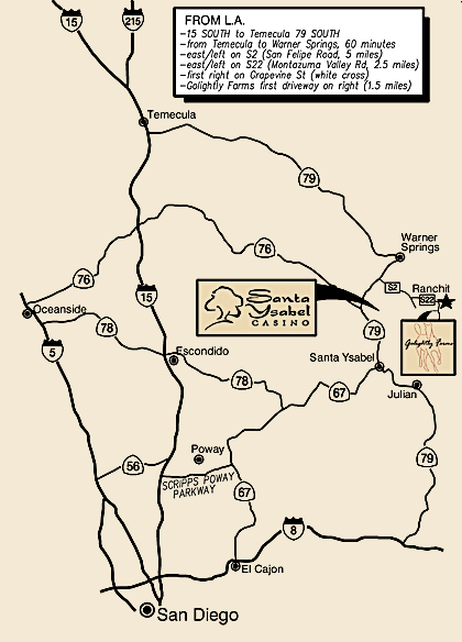
From LA
- I-15 South to Temecula
- 79 South to Warner Springs (60 Minutes)
- Left (East) on S2 (San Felipe Rd, 5 miles)
- Left (East) on S22 (Montezuma Valley Rd, 2.5 miles)
- First right on Grapevine St. (White Cross)
- Golightly Farms is first driveway on the right (1.5 miles)
- Golightly Farms Ranch, Ranchita -- Overview map:

Venue Form edit
| Name | Golightly Farms Ranch |
| Address | See Map |
| City State Zip | Ranchita, CA |
| Phone1 | |
| Phone2 | |
| Website | |
| Attributes | Outdoor |
| Features | Camping |
| Hours | |
| Cost | 25 for entire weekend |
| Capacity | |
| Note | Festival site |
| I | Attachment | Action | Size | Date | Who | Comment |
|---|---|---|---|---|---|---|
| |
ranchitarocksmap2.gif | manage | 29 K | 26 Jun 2014 - 21:23 | Raymond Lutz | Golightly Farms Ranch, Ranchita -- Overview map |
Edit | Attach | Print version | History: r4 < r3 < r2 < r1 | Backlinks | View wiki text | Edit wiki text | More topic actions
Topic revision: r4 - 11 Mar 2015, RaymondLutz
 Copyright © by the contributing authors. All material on this collaboration platform is the property of the contributing authors.
 Ideas, requests, problems regarding Cops? Send feedback


