
Border Security
This Page: copswiki.org/Common/BorderSecurity
Latest News
Background
This topic includes discussion of the border fence, and the larger issue of border security and immigration reform.
Immigration and Naturalization Service
Protects and enforces the laws of naturalization, the process by which a foreign-born person becomes a citizen. The INS (http://www.uscitizenship.info) also tackled illegal entrance into the United States, preventing receipt of benefits such as social security or unemployment by those ineligible to receive them, and investigated, detained, and deported those illegally living in the United States.
The INS encouraged relatively free and open immigration during the eighteenth and early nineteenth centuries, and did not question that policy until the late 1830s. Naturalization is the process by which U.S. citizenship is granted to a foreign citizen or national after he or she fulfills the requirements established by Congress in the Immigration and Nationality Act (INA).
Immigration Reform
View an Immigration Survey of San Diego County Voters Commissioned by the Immigrant Rights Consortium of San Diego County:
 M928 2007-08-01 Immigration Survey of San Diego County Voters -- Immigrant Rights Consortium of San Diego County
Research of human rights violations along the border:
 M929 2007-07-01 Human and Civil Rights Violations Uncovered: A Report from the Arizona/Sonora Border -- Border Action Network
Summary of articles submitted (Add | All)
 M1885 2019-01-10 Protest Govt Shutdown -- RayLutz CitizensOversight
 - M1129 2011-02-07 Virtual Warfare Escalates on US-Mexico Border -- Kanya D Almeida TruthOut
- M998 2010-07-27 CANDIDATE LUTZ SLAMS HUNTER'S SANCTUARY CITIES "GAG-ORDER" -- RayLutz Lutz For Congress 2010
 M995 2010-04-24 Duncan D. Hunter on Birthright Citizenship -- YouTube
 - M967 2010-03-21 Protesters march at site of proposed training facility near Ocotillo -- SILVIO J. PANTA IVPress Online
- M859 2009-09-25 San Diego County Sheriff Candidate Debate -- RaymondLutz CitizensOversight
- M851 2009-09-22 The folly of the fence -- Editor UnionTribune
- M873 2009-04-23 Ethics and Military Contractors: Examining the Public-Private Partnership. -- Mc Cain Conference Stockdale Center for Ethical Leadership, United States Naval Academy (Citizens Oversight)
 M735 2009-01-25 Photos - Border Fence in Otay -- Nathan Trotter
 - M659 2008-10-21 New Fence Will Split a Border Park -- RANDAL C. ARCHIBOLD NewYorkTimes
- M618 2008-08-22 Pat Nixon at the U.S.-Mexico Border -- Joseph Nevins New America Media
- M587 2008-08-09 Changing the immigration debate -- Marcela Sanchez UnionTribune
- M586 2008-08-07 Border Patrol detained activist who was filming -- Leslie Berenstein UnionTribune
- M583 2008-08-01 Smugglers Gulch + BLM proposing wind energy plans for the East County -- Rett Lawrence AbcNewsSanDiego
- M581 2008-08 Officials Hope To Expand County Wind Energy -- AbcNewsSanDiego AbcNewsSanDiego
- M734 2008-07-29 A Divided Friendship -- UCSD
- M564 2008-07-09 Mexican Torture Training Raises Questions About U.S. Military/Police Aid -- Laura Carlsen HuffingtonPost
- M567 2008-07-08 The Ballad of Esequiel Hernández Lesson Plan — Video Clip -- Kieran Fitzgerald Pbs Org
- M565 2008-07-02 US Private Contractor Leads Torture Training in Mexico -- Kristin Bricker Narco Sphere
- M585 2008-05-19 Could infighting end Minuteman movement? -- Kerry Lester Daily Herald (Chicago)
- M516 2008-05-16 Canyon supporters joining forces to stop fill-in work -- Leslie Berestein UnionTribune
- M509 2008-05-02 Southern California Residents Gear Up for New Fight to Stop Secretive Expansion by Military Firm Blackwater -- Amy Goodman, Raymond Lutz, Bob Filner DemocracyNow
- M500 2008-05 Border Tunnel Problem Worsening As Fences Go Up -- Stew Magnuson National Defense Magazine
- M501 2008-05 Want to Know How to Build a Virtual Fence? Ask Border Patrol -- Stew Magnuson National Defense Magazine
- M508 2008-04-26 Blackwater permit faces challenge - Public not informed, San Diego officials say -- TanyaMannes UnionTribune
- M506 2008-04-25 Southbay Leaders: Otay Blackwater Presence Will Complicate Border Relations -- AmyIsackson KpbsNews
- M507 2008-04-25 Blackwater-Otay Press Conference (Filner) -- RaymondLutz CitizensOversight
- M502 2008-04-24 Filner Protests Blackwater Development in South County -- BobFilner BobFilner
- M503 2008-04-23 Blackwater revives mission -- Security contractor plans training center -- AnneKrueger UnionTribune
- M487 2008-04-08 Power to Build Border Fence Is Above U.S. Law -- Adam Liptak NewYorkTimes
- M486 2008-04-01 DHS Exercises Waiver Authority to Expedite Advancements in Border Security -- Department of Homeland Security
- M390 2008-02-06 Dulzura Deception -- Ernie Grimm SanDiegoReader
- M413 2008-01-30 Border Fence NEPA (Marron Valley Road) -- Robin Brallsford COPs
- M378 2007-12-13 Blackwater Mercenaries on the USA-Mexico Border -- NancyConroy RINF.com
- M303 2007-11-12 USA-Mexico Anti-Drug Plan Includes ‘Private Contractors’ -- NancyConroy Mexi Data
- M216 2007-10-22 Blackwater likely to train Mexican drug warriors - Press release from Mexico -- Antonio Garza Mexican Ambassador to the United States
- M258 2007-10-12 Blackwater admits border security is a goal -- RaymondLutz CitizensOversight
- M164 2007-09-12 Contractors take on expanded role in drug war -- Katherine Mc Intire Peters Government Executive
- M928 2007-08-01 Immigration Survey of San Diego County Voters -- Immigrant Rights Consortium of San Diego County
- M929 2007-07-01 Human and Civil Rights Violations Uncovered: A Report from the Arizona/Sonora Border -- Border Action Network
- M62 2007-06-23 Wind Zero Presentation -- RaymondLutz CitizensOversight
- M593 2007-04-06 Escape clause | A sweetheart sentence for a repeat offender -- Editor UnionTribune
- M592 2006-12-20 Going after the big crooks -- employers -- Ruben Navarrette Jr. UnionTribune
- M591 2006-12-15 Guilty plea in hiring of illegal immigrants | Fence company to forfeit millions; execs face prison -- Onell R. Soto UnionTribune
- M590 2006-11-24 Company in inquiry built fence at border | Feds look for hiring of illegal immigrants -- Joe Cantlupe UnionTribune
- M589 2005-12-03 Company in trouble again over undocumented workers | Immigration agents call rehiring pattern cause for concern -- Leslie Berestein UnionTribune
- M588 2004-09-22 Fence workers held in security sweep | Company has contract with North Island NAS -- Leslie Berestein UnionTribune
Border Fence
See this clickable map of the border fence. -- http://americanpatrol.com/ABP/SURVEYS/BORDER-2009/SAN-DIEGO/HTML-SAN_/Sector.html
We need to work fast on this fence disaster because they are pushing it ahead an egregious assault on the environment. We tried to find out about the project from ALL the elected officials and got nowhere. We found out about the meeting on Jan 17th on about Jan 20th, the one at the convention center. I was told about two dozen people showed up. They also had a meeting in Alpine, but none along the border.
The big disaster about this is that even if they complete the fence, there will still be a ten-mile gap, in the most sensitive areas of Marron valley and the sacred Kuchaama mountain. To close those ten miles will be an unprecedented environmental disaster as the Tijuana river winds back and forth across the border area.
- Main project site: http://www.borderfencenepa.com/
The current proposal is 5.2 miles of new fence, 4.4 miles extending from the fence at Brown Field and 0.8 miles extending the fence from the existing Tecate fence. There is a big gap in the area of Marron Valley Preserve.
Marron Valley Preserve.
The Marron Valley Preserve consists of approximately 2,600 acres owned and maintained by the City of San Diego Water Department. This area has been designated "Cornerstone Lands" under the City of San Diego Multiple Species Conservation Program (MSCP) Subarea Plan because it is considered an essential building block for creating a viable habitat preserve system. Much of the area is currently leased by the city for cattle grazing, however as part of its designation as Cornerstone Lands, the city would place conservation easements on portions of the preserve, which then can be used as a Conservation Land Bank and sold as mitigation credits to public entities, public utility/service providers, and private property owners doing projects in San Diego County and needing mitigation (City of San Diego 1997). A small portion of the proposed primary pedestrian fence, Pack Trail access road, and one staging area would be within the Marron Valley Preserve near Boundary Monument 250. An additional staging area to be used during upgrades of Monument 250 Road would also be located within the Preserve, east of Mine Canyon Wash.
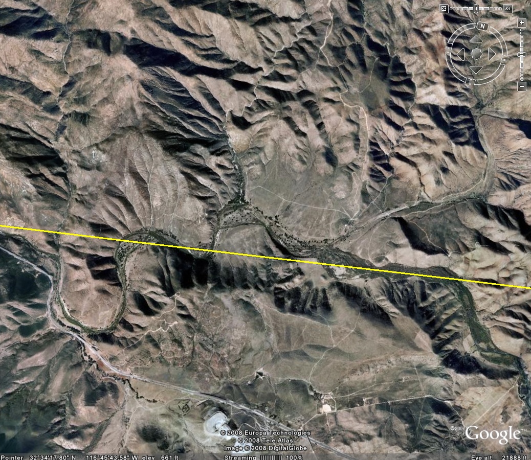
- Satellite Image of Marron Valley showing border. Note that the river crosses the border at least four times and runs exactly along the border line for perhaps a quarter of a mile.
There does not seem to be any discussion of changing Marron Valley Road, however there was suppose to be the document "Monument 250 Road Improvement Project" on this page: http://ecso.swf.usace.army.mil/Pages/Publicreview.cfm
- Photos of the fence are a big help to understand what exists and what is planned. See them here: http://ecso.swf.usace.army.mil/Pages/sdphotos.cfm
Key Problem (submitted by RaymondLutz to the NEPA process)
This proposed fence would be difficult to cross and will resist the impact of a vehicle. However, the extent of the fence does not fully span the border. There is a gap in the fence between the western portion (4.4 miles) and the eastern portion (0.8 miles) of approximately ten miles. This gap includes some of the most sensitive portions of the border region, including the Marron Valley Preserve and the Tijuana River. There was no analysis of the displacement of the border traffic into the gap, and putting severe pressure on the preserve areas.
The DRAFT ENVIRONMENTAL IMPACT STATEMENT mentioned that "during the 2006 calendar year, the Brown Field Station was responsible for 46,213 apprehensions, or 34 percent of all apprehensions within the USBP San Diego Sector." However, the document did not state how many of these apprehensions were of individuals who had crossed the border in the region of the proposed fence extension, nor did it describe the distribution of crossing traffic volume.
Questions: 1. What is the distribution of border traffic along the border at this time? 1. The reports says 46,213 apprehensions occurred in 2006 by the Brown Field station. Approximately how many individuals are not apprehended? A detailed map showing the crossing areas and approximate volume of traffic along the border (to defined question 1, above) is suggested, along with the approximate volume of individuals who evade apprehension (question 2). 1. Approximately how many individuals are crossing the existing fence, either by climbing it, using ladders, or digging tunnels? Where? 1. Extensive tunnels under the border in Otay and Tecate were discovered recently. Is there any proposed changes to reduce the prevalence of these tunnels? 1. Since there is a large gap of approximately 10 miles between the two fence extensions, what portion of the current undocumented traffic will simply move east (from the A-1 section) and move west (from the A-2 section) and enter in the Marron Valley Preserve and onto the Mt. Kuchama area, considered sacred by local tribes? 1. What is the environmental impact of moving the cross-border traffic into this preserve area, an area used as a Conservation Land Bank and designated “Cornerstone Lands” under the City of San Diego Multiple Species Conservation Program (MSCP) Subarea Plan because it is considered an essential building block for creating a viable habitat preserve system? 1. Very little consideration was given to detection technologies that could be distributed along the border and detect crossers without the extensive impact to the environment of border fence construction and avoiding the negative impact of moving the traffic further east. Would this be a viable alternative? 1. In photos of construction of other portions of the fence (esp. http://ecso.swf.usace.army.mil/photos/Image14.jpg), construction included a massive amount of grading that appeared to be unnecessary. Will the amount grading and road widening planned for the proposed fence be similar in impact as that shown in those photos? What is the impact on Marron Valley Road? Will this road be used for access to the area, both for construction and to apprehend border-crossers who must now walk around the end of the fence into this area? 1. Rumors have circulated that Marron Valley Road will be widened significantly. Is this true? What is the exact impact to this area and the residential community of Dulzura/Jamul?
Related Info
Discussion List
See ListServe for all email discussion lists and to add more. %KEYWORDTOPICLISTSERVE%